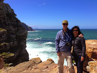
We were on a coastal drive of Cape Town and the surrounding area all day. When we arrived at the Cape of Good Hope, we saw that a lot of people (and there were a LOT there) were hiking up to the top of a cool looking rocky hill. We thought we'd hike it, and told our guide. He seemed a little surprised that we wanted to hike up it, but we told him that we've been sitting on our tuckusses a lot over the last week, and that a little hike sounded good. He offered to meet us "at the top" with his car. I took that to mean that the trail only went a little past what we could see, and that we'd hike up there, and there he'd be.
Boy, was I wrong!
We reached what I originally thought was the top, saw that it continued on, so continued with our hike. We kept on going, as the crowds thinned out, and at some point we realized, "oh, this trail goes ALL the way OVER THERE to the lighthouse!"
Good thing we brought water and Krave Jerky!
It was a GREAT hike - so gorgeous, as we were surrounded by beautiful rock formations, and the Atlantic Ocean the whole time. The weather was in the low 60s, and it was sunny and clear. Pretty ideal, really. Plus, I felt like I was getting in some good exercise - a first on this trip, really. :)
I didn't have my GPS Walk tracker on, and didn't bring my Fitbit with me on this trip. We probably hiked for one hour, fifteen minutes or so, so I'm guessing 2.5 - 3 miles. It was just lovely, and again, so pretty. I'm sure it would have been a "Linda Imlay Approved Training Hike". ;) Glad it worked out.

here we are at the Dutch sign for "Cape of Good Hope"

The start of the Cape of Good Hope Scenic Trail

starting our climb - I love stairs!

Richard and Pete starting off - this gives you a sense of where we started

selfie with the Atlantic Ocean

Dick, the Conqueror

A tourist going off-trail, and getting mighty close to an Ostrich. Tourist: 0. Ostrich: 1.
(just kidding - nothing really happened...)

Richard, Pete & Dick at what we originally thought was the top

the views were all so pretty!

this gives you an idea of how far/high we hiked at this point. After this, it was on to the lighthouse/parking lot where our guide was waiting for us

Dick, adding his touch to a rock sculpture

this gives you a sense of how far away we still were from the end. The parking lot is at the top right corner of this photo

picturesque shot of the great wooden trail and the lighthouse

almost at the end - looking back at where we had been


1 comment:
This is absolutely amazing! And, you are getting in some pretty significant training walks ;)
Post a Comment